Huwebes, Agosto 17, 2017

Mt Tapulao


Mt Tapulao 2037m/ 6,683 ft


Feb 19, 2017

SITIO DAMPAY BRGY SALAZA


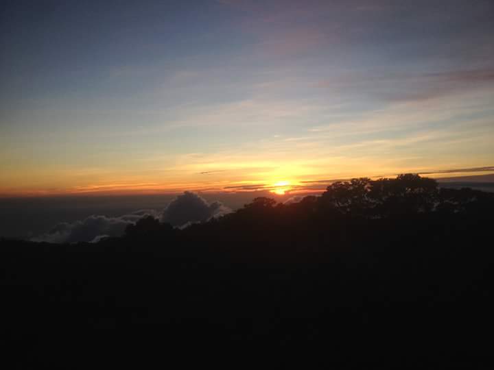
PALAUIG ZAMBALES-  5:04 am, As daybreak gave light to the horizon were bound again to the province of Zambales the second time, it was a nice calm Sunday morning. Packed with enthusiasm, we aimed to summit the highest mountain of Zambales region after a successful ascent of Mt Balingkilat in Cawag last month. Our itinerary was shortened to very challenging day hike.

Mt Tapulao was known to many mountaineers for its notorious 36-kilometer relentless trail filled with all kinds of rock, sand, dirt and obscure terrain. Not to mention the time we spent reaching its main jump off took us almost 8 hours land travel that almost drained our energy.


The good thing was the morning welcomed us with a frigid country side breeze as it was mid of February, it was a very fine soothing Sunday morning not until we commence our trek.


BACKGROUND

Mt Tapulao is a reminisce of Cordillera, in-fact it's weather is less likely resembled Mt Amuyao in Barlig mountain province alongside with some of its terrain. It's name derived from Pine tree which is Tapulao in the local dialect and stands at 2037 masl making it the highest Mountain in Zambales region.

Tapulao is popular not just to Mountaineers but also outdoor seekers and 4x4 enthusiast because of its trail that was often used for off-road driving activities. Its trail was previously built for chromite mining purpose but was closed due to environmental issues thus, environmental tourism started to flourish after its closure.


It has a more challenging 50-kilometer traverse trail known to advance climbers which start in Labney Mayantoc Tarlac traverse to Palauig Zambales. We have already plans of climbing Tapulao via Mayantoc traverse early next year.

The total time completion took us 16hours and 8mins for a very long day hike, our team was just composed of the blogger, Buboy, Mj, Thea and Sandy.


SITIO DAMPAY SALAZA BRGY HALL

7:45 am, we arrived on the main jump off and we had breakfast before commencing our long trek. Shortly after we arranged our guide and paid for the necessary fees plus few sets of stretching we commence our trek at around 8:38 am.


 The starting point


The trail started from km 1 at around 100masl, Short burst of energy kept us on fast pace on our way as we ascent we saw a glimpse of neighboring towns of Masinloc and the beautiful west Philippine sea.

The trail was composed of open rough roads filled with dirt, rocks and obscure terrain.


West philippine sea

It was past 11:00 am when we reached kilometer 6 marking which was the first water source.
At around kilometer 8 was when we had our lunch exactly at 11:34 am, shortly after 30mins, we recommence our trek until reaching the last water source and refilled our water bottles.


1:45 pm, We trek endlessly passing through the same terrain of rocks and dirt alongside with the sun's scorching heat that made our pacing sluggish


The weather was not soothing

Take 5 moments

That time one of our teammates had some minor pain in her foot, but the good thing was we brought first aid kit and mefenamic acid to ease her pain. 


We reached Kilometer 11-12 at around 2:30 pm, our path was covered with fog and clouds, estimated at 1800m altitude


we had some few moments that restored our vigor.


Self-camera

We continued until we reached kilometer 16 at around 5:00 pm. After almost 9 hours of trekking.


Take 5 moments


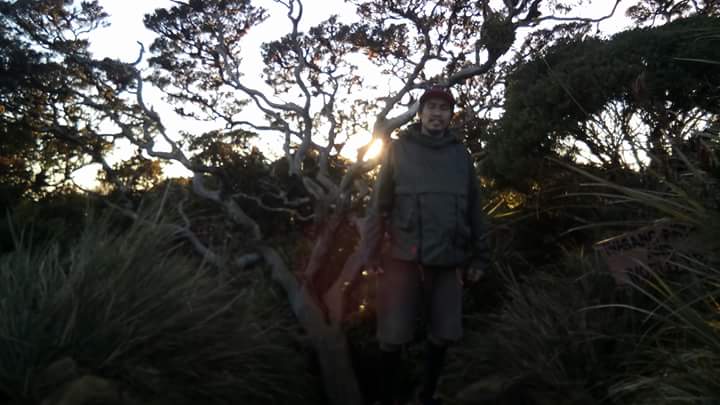
 Kilometer 16 was filled with pine trees and had good spots for camping. The wind breeze was freezing especially at night Because of it's attitude at 1900m.


Sandy had to renounce her trek on kilometer 16 as she was very exhausted that time and had to recuperate her energy. Eventually, we didn't waste time and recommenced our final assault to the summit. We ascent up through the forested part which was filled with pine trees that resembled Marlboro country of Mt Pulag in Benguet.


A reminisce of Mt Pulag

5:30 pm, the breeze was frigid roughly around 14-16 degree Celsius we entered the mossy forest, I changed my tight fit attire to a loosen trekking pants so that I could move swiftly. As we ascent up the mossy forest, my water bottle ran out. 


One of my best shots

I eventually turned back without knowing that I'm just 15mins away from the summit. Mj and Thea agreed to meet up on the spot where Sandy was located, while Buboy was already at the summit.


Buboy

My teammates had nice shots of the sunset at the summit, the summit was an open area with a world tree alongside. Soon after, they returned from the summit 20 minutes after I came back. We regrouped on the spot where Sandy was resting. It was already dark and cold.


The summit

6:45 pm, We ate our trail foods and prepared our headlamps after 15 minutes we started to descend. Darkness already engulfed the sky, we saw a large group of mountaineers camping on kilometer 16. We were the last team to descend that day. 


We didn't waste time as we've estimated a long 6-7 hours trek down and it was already 7:10 pm. I switched on my very reliable head lamp around 200-lumen capacity as I gave a very bright light on the trail head. 


Dawn

8:30 pm, We trek down relentlessly without noticing we arrived on the last water source after an hour. Immediately, we refilled our water gallons and consumed all the last trail foods we have.


We trail run down passing through rough roads and just spent 5 minutes for every 45-minute trek interval just to restore our vigor. Our trek was relentless. Our pacing was very fast we almost run while descending.

10:45 pm, after almost 3 hours of our fast pace trek some of my teammates already felt the exhaustion, and the lingering fatigue, just to add the sleepless night prior to this trek and hunger stressed out our burden and we were still on kilometer 5


take 5

 I still have the energy and enthusiasm to continue for 4-5 hours thanks to my very flexible trekking pants and 3 liters of water, however, the problem was my teammates were already tired, we didn't lose hope and cheered for one another.

With renowned vigor we recommenced our trek after resting for 20minutes and descended again on a fast pace, Mj was the sweeper assisted by our guide Thea and Sandy were in the mid.

11:00 pm, Bubuy and I decided to advance the whole team without declining our pacing. 
We noticed that the last 3 kilometer was the longest part of Mt Tapulao. We thought that the spirits of the mountain were fooling us drastically, every sharp turn from the rough road seemed identical, we thought that we were being toyed. 


But the hope of a hot native Tinola and rice kept us motivated on our way down. Our momentum didn't declined although Starving, We never bothered hunger like we're running in a hunt for our prey.  We rum down until we outreached another team that was also descending the last kilometer. They all look worn out and just walking gradually. Out of context I greeted them, but they didn't respond a single word. Hurriedly we advance on them it was 11:45 pm.

I was very eager to finish the climb and my stamina was at its highest peak, after 20 minutes at 12:10 am, we finally reached the guard house, marking the end of the very long trail. I look back and saw tiny lights from other climbers as they were descending bit by bit.

Buboy rested as I placed my head lamp on the road adjacent to the guard house to signal the other teams. I did that just to give them assurance of hope that the light was the finish line. While waiting we sat on the guard post reassessing the whole climb.

 Soon after 15 minutes, Thea arrived very exhausted and worn out. She can't barely walk. I congratulated her and welcomed her to our climbing organization. Although she was wasted, I can tell that she was very happy after accomplishing the trek. After 10 minutes Sandy, Mj and our guide finally arrived.

We finished the whole descend for just 5 hours and 11 hours for the ascent, making a total of 16 hours for  a very long 36-kilometer day hike. That distance is from Magallanes Interchange up to Calamba Exit Toll via Slex.

12:40 am, we walk bit by bit until we reached the Brgy hall. We were dismayed because there was no Tinola waiting for us. We just ate cup noodles and our guide shared some of the food that was available that time. Soon after, we freshen up and took a chartered tricycle to Iba Zambales

2:30 am when we reached Iba Zambales and rode a bus to Manila we reached Manila 7:30 am


Mt Tapulao was surely one hell of a trail and off-road combined. Reaching its pinnacle, one must possess a solemn heart filled with patience and persistence before one could see her distinctive beauty. If there would be an ice cream that best soothes for Tapulao all I could say is a very rocky road with fortified rocks on its topping. 

Its length will test your patience and faith, reaching its summit is one of the best accomplishment you can experience while climbing it, just to add, bring a lot of stamina and persistence. If we could compare climbing Tapulao to a very beautiful lady like Maria Makiling I can say it would be a very long courtship. Till next climb.


MT. TAPULAO
Palauig, Zambales
Major jump-off: Sitio Dampay, Brgy. Dampay-Salaza, Palauig
LLA: 15.4833 N, 120.1166 E, 2037 MASL
Days required / Hours to summit: 1-2 days / 6-12 hours
Specs: Major Climb, Difficulty 5/9, Trail class 1-3
Features: Pine forests, views of West Philippine Sea


-pinoy mountaineer


Sabado, Hulyo 22, 2017


Mt Mariveles 4,100ft (PANTARAK TRAVERSE)


GABON SITIO DUHATAN, BAGAC 
April 17 2017

BALANGA-  3:00 am, As I reminisce the endeavors of the past exactly a year ago, I was nostalgic on my way to Bataan, having the thought of Mt Mariveles lingered my memories on Tarak Ridge a year ago. Prior to that, We've planned to climb Pantarak many times but never materialized. Only on the second week of April after a failed attempt to trek Kibungan Cross country in Benguet, the plan manifested into life after we settled for plan B which was traversing Mt Mariveles via difficult route.
Known to many mountaineers and outdoor enthusiasts as PANTARAK, the abbreviation of Pantingan Peak Traverse to Tarak Ridge.

It's 23 kilometers of arduous trail and multiple peak assaults again tested our adaptability and knowledge on the outdoors. This blog covers our story of climbing multiple peaks in one distinctive mountain.


BACKGROUND

Mt Mariveles was an extinct volcano located in Bataan peninsula, It is composed of rolling hills, steep trails, with thick vegetation, cleanest rivers, and multiple peaks altogether in one Mountain range. Its creator is home to some uncharted jungle terrains that are waiting to be explored. Mt Mariveles has many other peaks alongside with Pantingan peak and Tarak to name a few. Its highest is what they call Bataan Peak (1400m). Thanks to the efforts of early exploration teams led by Sir Sky Biscocho Pantarak trail was established.

Definitely, not for beginners, the total time completion of the whole traverse took us 32 hours and 18 minutes including camping time. Altogether our team was just composed of the blogger, Jissa, Gerald and my good friend Lemuel.


SITIO GABON TO DANNY'S GATE UP TO PANTINGAN PEAK

We arrived in Bagac Market at exactly 6:30 am, we bought food supplies that would be needed for the overnight trek and having no courtesy to Mr. Rey or tatay rey made some delays on our itinerary. After reaching the main jump off, we immediately settled our climbing permits to Tatay Rey, one of the most experienced guides in Bagac side.


After settling some undisputed fees plus a short briefing and few sets of stretching we commenced our trek at exactly 9:10 am


River crossing

The first segment was composed of rough roads until reaching the forested part of the trail, from there we crossed 3 rivers and refilled our water bottles until reaching the rolling hills they call Marlboro country, from there a preview of Pantingan summit was more visible.


take 5 moments


A reminisce of Balingkilat

 After passing through the rolling hills the sun vibrantly scattered its luminous light and heat, on our way up to Danny's Gate. It was composed of open trails with tall dry grass that blocked the wind and made us very exhausted and exposed to the radiant heat.


Direct Heat


We cooled down after passing through Danny's gate and prepared our lunch, Little do I know that moment I forgot to bring one of the most important equipment for cooking which was a butane gas!


We immediately decided if we will renounce our trek or persist but to my surprise, we all corresponded to the same thought of recommencing our trek. The good thing was we bought so much trail food as an alternative to the main course.


Nap time waiting for our sweepers

12:30 pm, With renowned vigor, we resumed our trek up to the forested area, until passing through the first steep inclination.


Vibrant colors of nature

It was already passed 3:00 pm we were trekking up to the ridge when we encountered a 2-meter long snake that passed through our path, shocked, we gradually declined our phasing. Our guide Tatay Remy immediately draw his bolo, luckily! the snake moved away from our location and it seems hunting for its prey.


We recommenced our trek after waiting for our sweeper Gerald, from the ridge we've managed to trek for 1 hours without declining our phasing until reaching the final inclined assaults up to Pantingan at 4:25 pm. 


There were good viewpoints that we used to capture some nice shots of the Bataan peninsula and the West Philippine Sea.


West Philippine sea

Exhausted, we summited at around 4:45 pm reaching Pantingan peak after 8 hours from Tatay Reys house, From Pantingan Peak the whole creator of Mt Mariveles can be seen.


Pantingan Peak

We stood still on the pedestal of the mountain range and delightfully enjoyed the marvelous sight that it could offer.


Mt Mariveles Creator

The original Itinerary was to reach Bakwat river before dawn but the plan was renounce due to itinerary delays, thus we decided to e-camp (emergency camp) on the other side of the ridge and trekked for an hour before we could set our tents.


The camping ground can only accommodate 3 tents. We gradually had a difficult time fitting our tents on the limited space it had. 


Darkness engulfed the horizon as nightfall arise, followed by a stiff breeze hence a high wind chill pounded some of the shrubs around our camping site. Good thing we successfully set up our tents at exactly 7:00 pm.

We had some socials time spent but due to the lack of fire, we couldn't boil water and just ate some of our trail food.

Lights out at 8:00 pm!


DAY 2


PANTINGAN PEAK TO BAKWAT RIVER


Good Morning

The next morning we woke up at 5:00 am, we were so exhausted last night we slept for 9 hours, the night was frigid and the morning greeted us with a dewy gloomy weather.

Lemuel

We immediately packed our things, prepared a cold coffee and had a short briefing. Bakwat river is located 500 meters below our camp site so we had break camp at exactly 5:35 am and by 5:40 we resumed our trek.


Slippery descend

The hope of a fine weather was downhearted by the dim sky, we reached the detour to Bataan Peak after 20 minutes, from there we descended 2 hours before we could reach Bakwat river at 7:44 am.


Take 5 

The trail was slippery and needed contortion skills and cautiousness to some extent and the trails were entangled by mossy tree vines.


Bakwat River

Bakwat River was the resting point of Mt Mariveles, only Mountaineers can reach this part because of its entangled and steep down ward trails. Also, there were many reports of missing mountaineers from this area good thing tatay Remy is an expert on this mountain.


After 20 minutes we resumed our trek up to Vinatana peak which was 3 hours away, with full gear back packs we ascend gradually up to some rope segments that we grasped until we could reach the ridge going up to Vintana Peak.


Rope segments

We summited Vintana Peak at 10:45 am and had some few group shots for 5 minutes, shortly after with renowned vigor, we trek up to El Saco peak. 


Vintana Peak

The trail from Vintana to El Saco Peak was the steepest part of the whole Pantarak it needed hand support for grasping large vines before one could gradually ascend up.


Pantingan peak can be seen hiding on top of the clouds

Although it was just more than an hour away from Vintana peak, it pounded our legs hardly that I cannot barely walk later that week. 

It offered also an enticing scenery of the previous peaks we summited.


EL SACO PEAK TO NANAY CORDING


The view Mariveles City

We summited El Saco Peak at 12:06 pm, we had a good 20 minutes spent on the summit after catching our breath from the steep ascends. 


El Saco Peak

From there a very swift one hour descend down to Tarak Peak. It was already passed 1:00 pm when we reached Tarak peak after passing through some entangled obstacles that resembled wild bore trail of Mt Makiling.


We were starving! We haven't eaten rice for the past 28 hours since day 0. The worst thing is our trail foods were already low.


Gerald

We reached Tarak peak at 1:05 pm, The view was very enticing, with an awesome panorama of Corregidor Island and Manila Bay. We just spent some 20minutes of pictures on Tarak Peak and swiftly descended again to the known Tarak Ridge which I climbed a year ago.


Tarak Peak

2:30 pm, when all our trail food was gone, from Tarak to Papaya river we approximated 1-hour trek on fast phase. Hurriedly we trail run down reaching the forested part. While descending It rained heavy leaving the trails filled with mud as thick as 2 inches.


Tarak Ridge

We reached Papaya River at 4:00 pm while the rain drizzled. Starving and shivering we pushed our last energy and resources until reaching Nanay cording's place at 6:40 pm.


Jissa and Gerald reached Nanay Cording's place 30 minutes prior to our arrival so they already prepared our dinner.


6;45 pm, At last! We arrived starving, shivering and exhausted our lingering fatigue was replaced by a nice hot soup and viand alongside with nice warm rice plus a hot coffee that undoubtedly restored our vigor and boosted our morale.


All I can say that time was Rice is life! After 32 hours of trekking without it, It felt like a reward for reaching the finish line. After we had dinner we bid farewell to our guide tatay Remy.


23-kilometers trail

After we freshen up we departed at exactly 8:00 pm via Bus going to Balanga central terminal.  We reached Manila by 12:30 am the next morning


PANTARAK was a test of toughness and endurance, It gave us an essential lesson that every mountain should be treated solemnly regardless of one's readiness. It has a rank difficulty of 8/9 based on other reviews but it was surely a tough adventure for anyone who seeks a real kind of endurance and adventure at the same time.


Entry Point: Sitio Gabon, Brgy. Saysain, Bagac, Bataan
Exit Point: Brgy. Alas-asin, Mariveles, Bataan

Total completion 32 hours 18 minutes for 2D/1N itinerary
Highest peak 1388masl