Sabado, Enero 6, 2018

Mt Ugo Traverse


Mt Ugo 2150 m


Perhaps climbing a mountain is like connecting to something, like falling into pit of oblivion and waking up enchanted with its charm. perhaps love transcends into everything, like how the flowers blossom after the rain, indeed, a universal language that anyone can understand, if you found it cherish and protect it"


Nov 17 2017
Kayapa Nueva Vizcaya
5:05 AM


I was delighted going back to Cordillera, after successfully climbing Mt Kinabalu in Borneo last month and were all set again to do our year-end climb,.

Traversing 33 km from Kayapa Nueva Vizcaya to Itogon Benguet via Mt Ugo was not easy as it sounds. But climbing one of the great cordilleran traverse dubbed by Dr Gideon Lasco of Pinoymountaineer, was a rewarding experience.

Its unique trail will offer you one of the most enticing scenery in the Cordilleran region and will take you to some isolated communities of the higher Cordilleran people.Cordillera is close to my heart like Mt Ugo is considered one of the gateways to the Cordilleran Mountain range located in the southern part of Benguet.

I was very enthusiastic going back not just because of its scenery but the feeling that struck my heart 3 years ago when I was experiencing great depression. It was like love at first sight, throughout the years of climbing Cordillera made me realize that life was very beautiful and meant to be lived.

Just to add Mt Ugo is one of the best climbing destinations if you are looking for a great scenery for backpacking and camping because of its countless of Pine tree forest, ridges and hanging bridges,  that are interconnected to local communities via community trail.


BACKGROUND


This mountain was accidentally discovered after a tragic incident happened June 26, 1987, flight PR 206  bound to Baguio and crashed just few hundred yards below its summit all of its passengers were killed.  It has an altitude of 2150m much smaller than the lofty heights of Mt Pulag and Mt Tabayoc respectively which are also in the same region of Benguet.
located between the borders of Nueva Vizcaya and Benguet, traversing this mountain demands physical preparation to some extent. but its rewarding scenery will delight your sight like trekking its ridges will make you forget that you are still in the tropical country of Ph.

The temperature in Mt Ugo can go down to single digit especially in December to March season but not as much as the complex weather conditions of  Mt Pulag that go down way below the freezing point.


The whole traverse took us 30 hours and 18 mins for a chill weekend climb plus camping sessions which was the most awesome part of climbing UGO.


Kayapa town proper Nueva Vizcaya

UGOEn

We arrived at exactly 7am in the morning of Dec 17,  after traveling 7 hours from Manila to Aritao, and 1 hour To Kayapa from Aritao,  The team composed of Anica, Surren, Alex, Jade and Me the blogger made our way to the town of Kayapa via bus from Manila and Chartered van from Aritao. We geared our stuffs, bought supplies and made a courtesy to the local community fo Kayapa before commencing our trek.

The goal was to reach Benguet via Mt UGO in 2 days before exiting Baguio City

We aimed to reach Indupit village home to the Ibaloy tribe before lunch so that we could camp near the summit by dawn. We had our heavy breakfast before commencing our trek, climbing Ugo was my 25th mountain this year after climbing several major mountains one of it was Mt Sicapoo which was a 9 mountain traverse.


My teammates were enthusiastic and affiliated with several locals trading some root crops via community trails from Kayapa to other towns in Benguet, We passed through other local Barios before reaching the first resting place at around 11:00 am We cooked our early lunch and had some siesta time before recommencing our trek to Domolpos village.


12:30 we passed through the markings of the paved road, it was obscure, most parts of the community trails were undeveloped, the beauty of climbing mountains is you have the privilege to see this places that most of the people don't see. some are good but some are not, some were an eye-opener, seeing it was like a double dagger pointed in the heart, to see such situation and people untouched mostly by civilization without proper access through health care and other basic needs from the government was heartbreaking.


We arrived in Domolpos village at around 4:00 pm,  I met a strong Mountain Lady from the Ibaloi tribe, we fetched some water in her backyard that we used later that evening for cooking.

I
I remembered Nanay Cording from Mt Mariveles when I spoke to her and she cannot speak Tagalog. She speaks fluent in Kankanaey, Ibaloy, Igorot and some Ilocano words and she was 96 years old. Jade who is also a native Ilocano cannot barely understand what she said to us but I think she thanked us. They were not wearing any foot protection, like the other children from Indupit, one of our projects this year is to donate footwear to the Highlanders of Cordillera.

Cows everywhere


We bid farewell and gave some chocolate to some children as a token of appreciation for the water she gave us.


Hospitality from the highland people was very common, That's why I think mountain people were very blessed even though they lack the basic necessities in life, they were blessed in terms of health and other simple things we always neglect like the clean air we breath.


5:00 pm we continued to trek up to the south-east ridge of Mt Ugo where we camped and stayed overnight we had some several climbing groups ahead of us they were large groups others were support team.

Camping 101

We pitched our tents and started to camp at exactly 6:00 pm, The wind pounded our campsite heavily at around 50 kph. I to cooked Pork Caldereta and rice, by 7:00 pm I was already finished. We ate our dinner and started to rest at around 9:00 pm after few shots of Liquor, I was very worn out and the temperature was at 13-14 degree Celcius.

Chef skills

The presence of cows near our campsite was not new to us, in fact, celebrity chef and food blogger Erwan Heussaff blog about it when they climbed UGO via backtrail from Tinongdan village last September together with one of my Idols in trail running Koi Grey. Our campsite was big that it catered 18 tents alongside with ours.


10:00 We geared our thermal wears and sleeping pads, I was with Suren and Alex, Danica and Jade were in the other tent. We slept while The night was frigid and the wind blew hard and pounded our tent heavily until 6.00  am the next morning. It had my tent racks shattered into pieces.


DAY 2

MT UGO SUMMIT TO TINONGDAN VILLAGE


Sagada Arabica

5:30 am, The sky was gloomy and frigid, the sound of the rampant northern wind woke me up, It was shattering and echoing throughout the horizon and beyond, like a sound of dreadful spirits of the mountain suppressed and constrained.


I felt the first chill when I got out of my tent, immediately I boiled water so that I could brew coffee to ease the shivering . Jade woke up 10 mins after I got up, As I boiled warm water bit by bit the first light illuminated the sky at 6:00 Am. I prepared breakfast and cook rice.

Calderta ala Mt Ugo


Sisig

I cooked Sisig one of my favorite dish and preheated the Caldereta we had last night, I still had Pasta ingredients for lunch. Alex and Suren woke up afterward we had our breakfast at exactly 6:40 am and had our photo ops until 8:00 am.

Freezing @ 11 degrees


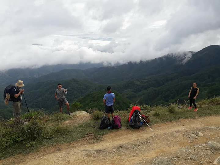
We had break camp at 8:15 am and recommenced the summit assault which was just 15 mins away from the campsite. We reached the summit exactly 8:35 am at around altitude 2150 masl almost half of Mt Kinabalu's altitude.


The summit was covered by lush floras and bushes that resembled Peak 2 of Mt Makiling, Beyond that, it had a marking of the tragic incident happened 30 years ago, from the northern side we saw Mt Pulag and Tabayoc which were very visible to the naked eye since we had good clearing.


We descended 15 mins after we arrived at the summit, we anticipated the long trek to Tinongdan which was 6-7 hours away.

.
In memory of Flight PR206

 While descending we saw Baguio City from a distance an indicator that we were already in Benguet side. Tinongdan side was very beautiful compared to the Kayapa side, It was filled with countless of pine trees, beautiful ridges and rice terraces that resembled Maligcong in Bontoc and Mayaoyao in Ifugao with a touched of Akiki trail in Duacan.

Mr nice guy Suren

9:30 am, We descended of fast pace without intervals of rest, we passed through the pine tree forest which had a twilight aura,  it was sublimity. I admit that trekking this part of Mt Ugo gave me another perspective of Cordillera, all throughout the years of climbing this region It did not fail to offer something new, something to reflect on, something that altered my perspective on life and gratitude.

      Go pro Hero 5

It was like an awakening, a true connection with nature, I stop to reflect on that solemn moment  and thanked the creator for the marvelous sight. I must admit that I am really a nature lover.
Suren and I were the sweepers while Alex, Danica, and Jade were the lead pack.

The cows from Erwan's vlog


11: 30 am we arrived in Lusod village which was the first campsite for mountaineers after trekking relentlessly for 2 hours passing through the pine forest and rice terraces. Lusod had a little community on it. They had a nice irrigation system and some ancient houses and rice paddies we geared down for 30 minutes after our vigorous trek that undoubtedly diminished our vigor, we had some siesta time spent throwing our habit of Hugot lines and infamous jokes while trekking especially Alex was with us.

Rice terreces

passed 12:00 we decided to continue our trek down we all agreed to have our siesta moments and late lunch in La Trinidad Benguet since Jade was from La Trinidad, I wanted to cook pasta in the outdoors but we anticipated the Logistics concern in Itogon especially at night because there was no public transport in Tinongdan and we forgot to arrange our logistics in Tinongdan when we were back in kayapa town.

Tinongdan Village

We trekked again relentlessly without slowing our pacing, until we reached Tinongdan village after passing several lower mountains at 3:30 pm, Tinongdan village had the same features like the other villages of Batad and Bontoc. The local community of Tinongdan resembled the village of Pat Yay in Ifugao, It has its own rice terraces and ancient cordilleran houses, the community road interconnected through mountains was significant for trading purpose, the local community gave us a warm welcome when we reached Tinongdan in exchange we gave all our trail foods to the children we met along the way.


4:00 pm the exit point of Tinongdan was a suspension bridge 40 meter long, suspended at 100 ft above the air. we were very thankful we reached the end of the journey after traversing 33 Km total distance. As it was mid of December.


The exit point had paved roads logistically challenging and a bit difficult to reach thats why it was beautiful. we made a courtesy call to the local Brgy officials they greeted us with warm smiles and arranged our chartered  monster jeep going to Baguio City.


We reached Baguio at 6:00 pm and spent the night in Jade's house in La Trinidad before going back to Manila the next morning.


Mt Ugo was definitely not your easy walk in the park  year end climb but surely It had me reminisce of the great memories I had throughout the years of climbing this region, All I could say is that I am still in-love with its people, its scenery and its hidden beauty that constantly making me want to come back again and again. truly It was love at first sight..


Til next climb.


MT. UGO (2,150+)
Nueva Vizcaya and Benguet
Jump-off points: Kayapa, N. Vizcaya; Brgy. Tinongdan, Itogon, Benguet
LLA: 16.31916°N, 120.80166°E, 2130 MASL
Days required / hours to summit: 2-3 days, 9-10 hrs
Specs: Major climb, Difficulty 5/9, Trail Class 1-3
Features: Pine forests, highland villages, views of Cordillera peaks

-Pinoy mountaineer


Huwebes, Nobyembre 30, 2017

Mt Kinabalu


Mt Kinabalu 13,350ft
Ranau Malaysia


“Why do we have to listen to our hearts?" the boy asked.
"Because, wherever your heart is, that is where you will find your treasure"

-Paulo Coelho The Alchemist


Sensi Backpackers Inn
Nov 11, 2017
3:30AM

KOTA KINABALU- I've been busy last month in the office with work I just had a month to finally prepare physically after my training climb in Dingalan Aurora last 2 weeks and my major climb in Mt Sicapoo last month in Ilocos Norte, furthermore, I had few sets of jogging, higher resistance training, and treadmill before our target date. This climb was one year in the making and probably the main highlights of 2017 as well.

Organized by me as the Expedition Leader and with the help of my friends especially Drew my climbing buddy from Kuala Lumpur as the expedition support. Our aim was to reach one of South East Asia's prominent highest peak which was Gunang Kinabalu or Mt Kinabalu in Bahasa language and one of three in the East Asian trilogy saga of Mt Yushan (Taiwan) and Mt Fuji (Japan).

Both respectively distinctive in their countries of origin.

Probably its the highest altitude record I've climbed as of the moment It was half of Mt Everest in terms of altitude and so far the coldest place I've been this year, colder than our very own Mt Pulag in the Cordillera region.


BACKGROUND


It was 1851 when the first known documentation of this enormous mountain was first made by a British explorer/naturalist Sir Hugh Low, but He didn't reach its summit not until 1888 after John Whitehead a British naturalist, successfully reached the Low peak the highest point of Mt Kinabalu.


Towering at 4,095m or 13,400 ft it is considered the highest mountain on the Island of Borneo and Malaysia and way higher than our very own Mt Apo (2,954m) and Pulag (2922m) respectively. Its prominence is one of the highlights of climbing the region of South East Asia relatively significant to any climbers who want to finish the Asian Trilogy

The temperature in this mountain can go way below the freezing point especially in January  there were reports of frost formations thus high altitude equipment and thermal gears were a major requisite. It's complexity and beauty was exceptionally remarkable from the mountains I climbed back home, It felt like it has its own alluring beauty that has not yet been discovered, ranked as the 20th most prominent peaks of the world by the UNESCO WORLD HERITAGE SITE.


Although I don't consider Mt Kinabalu as a tough mountain to climb like the colossus ranks of  Sicapoo, Mantalingahan and Halcon way back home that will take you almost a week to finish, But its complex conditions and high altitude were the main variables to challenge us that I almost had colds and swollen leg muscles later that week.

The threat of hypothermia and High Altitude Sickness can be imminent while scaling her so proper Conditioning, and Acclimatization process were very essential precautionary measures.


Every year thousands of Mountaineers and Outdoor Enthusiasts from all over the world visit this prominent mountain and issuing a climbing permit to scale her was limited to only 150 climbers per day after the tragic Earthquake that struck Borneo in 2015 that killed 18 people in this mountain they limit the numbers of climbing permits. We were lucky we got our climbing permit via early booking online via Sutera Sanctuary Lodge


KINABALU NATIONAL PARK


 9:00 am, We arrived in KNP (Kinabalu National Park) after almost 3 hours of land travel from Kota Kinabalu City and 2 hours flight from Manila. We also slept for just 3 hours in Kota Kinabalu and bought our supplies before heading to KNP. The team was composed of 5 Pinoy climbers and a Malaysian Guide. They were Mara, Marnie, Dartz, Drew and me the blogger.


We immediately prepared or gears and arranged the remaining permits and fees before starting our very long trek up to Raban Lata Lodge one of the highest lodges in Southeast Asia. We met our guide who was also from a native tribe in Sabbah and was expert in English as well his name was Mr. Sai.


We had a brief discussion on what to expect since this was the first time we will climb Kinabalu, he warned us on the possible dangers and difficulties we could face for our morning assault tomorrow. But since we were experienced climbers back home we were always expecting the unexpected.


10:00 am, The main jump-off was Timpohon Gate, from KNP office it was 20-30 mins drive up, we arrived at 10:30 am and commenced our trek at exactly 10:45. The whole trek was just 18.75km distance including back-trail and will start at roughly 2200 m altitude above sea level almost equivalent to Mt Sicapoo's summit. 


The trail was very established and well preserved by local authorities unlike climbing mountains way back home were a total of wilderness can be experienced. It was short in terms of distance but it was a very steep ascent.


Its diverse terrains have spawned a wide variety of plants and animals like the endemic  slender squirrel or the gigantic Rafflesia and you are far more likely to appreciate them by walking some from the lower trails.


We had short take 5 rest for every Kilometer we reached, the wind and scent of nature were very nostalgic It had me reminisce about the mountains I climbed way back home.


We met other Asian and European based climbers, some of them were British I had a short conversation with a British based climber his name was Tom, he said he scaled Kinabalu twice and had successfully summited this mountain yesterday, He told me that it was very beautiful up there and they had good clearing. It had me anticipated on what to expect on our morning assault tomorrow. 


3:00 am, Rain started to downpour. We continued to push through until we reached KM 4.5 we took photo ops for every Kilometer signage and had to throw some hugot lines which we frequently do every time we felt discomfort while climbing.


I've had a long conversation with our guide Mr. Sai he was guiding in this mountain since 1997. He was born and raised in Sabah He told me about the history of this mountain I was amazed by how well he knew so many facts about Kinabalu since he was a 5th generation guide and a descendant of his great-great-grandfather who also guided Sir Hugh Low on the first known documentation of Kinabalu way back 1851.


Mr sai

He just recovered from the tragic incident that happened 2 years ago when Borneo was struck by a powerful magnitude 6 earthquake that killed 18 climbers all of them were on their way up via Ferrata trail some were still wearing harness and ropes when rocks fell on them. He told me that rocks as big as a house fell from their position and had disintegrated some of the victims badly unidentified and injured more than a dozen other people.


Locals blamed a group of European Climber who strip naked on top of Kinabalu a week prior to that tragic 2015 incident. It was for the first time, Legend says that it was a way of the mountain to teach a lesson, Locals believed that the mountain spirits punished them for their insolence against its sacredness. 


Local species

Immediately, Local guides and some boboilan or priestess performed Monolob a ritual that was practiced hundred of years ago as a way to give peace offering to the spirits of the mountain. They've done it every year since that incident.


Kinabalu's name was derived from Aki nabalu, which mean resting place of the souls of the departed


5:00 PM, We reached km 5.55, almost half of the trail the rain stopped as we were on the last resting place before Raban Lata which served as our Base Camp for the night.


We met a physician named Dr. Radi who was also on his way up to Raban Lata, We didn't knew that he was also the president of Rotary Club of Kota Kinabalu, not until we had a chat. We immediately became friends. He was amazed by how young people were getting more involved in the outdoors. I joked him that he was still young, young at heart which made him laugh eventually building a great rapport

He climbed Kinabalu for more than 45 time since he migrated from India and he is now 62, His wife died early and He have two daughters as well


He told me that they were raising funds for the indigenous tribes of Sabah by climbing the 3 highest mountains of Borneo, He was well respected man. I invited him to visit the Philippines which he said he will soon.

I was amazed by his compassion and enthusiasm for others, his dedication to what he believes as an elder and an outdoor enthusiast. I really admired his heart. Someday I want to be like him, I've been a volunteer for the less privileged especially the highland people way back home. Perhaps people with compassion were naturally close to my heart.


6;00 pm, We finally pushed our final assault on the last kilometer before Raban Lata, with the renowned vigor we trekked up as darkness totally engulfed the horizon with a sublime sunset scenery


Bit exhausted we reached Raban Lata Lodge at 6.45 pm at altitude 3000 m, It was cold roughly around 8-9 degrees Celsius.


Raban Lata Lodge was like a sanctuary for exhausted climbers, located at 10,000 ft above sea level, It was way higher than our very own Mt Apo. It has facilities and other equipment like heaters and rooms that were very useful since it was freezing. We had our dinner buffet style but we were worn out as well, probably because our bodies were adapting to high altitude.


Raban lata was designed for acclimatization process for climbers to avoid Altitude Sickness or H.A.S for High Altitude Mountaineering or mountains above 10,000 to 30,000 ft


We had good room with heater as well with 6 bunker beds and a comfort room, The water was frigid, we had to heat our water so that we could wash up. After a short briefing with Mr, Sai  we prepared our equipments and thermal gears for our early morning assault by 9.00 pm lights out.

The night was frigid we had to turn our heaters on.


RABAN LATA TO LOW'S PEAK


1.30 am, The next morning we woke up early and just had 4 hours of sleep, but since our gears were already prepared immediately had our light breakfast. We saw other climbers from different countries preparing as well, We met Mr Sai and had short briefing on what to expect.


We commenced our trek at 2:35 am, the aim was to reach KM8 before 5:00 am since park rangers only allow climbers to do the summit climb not before 5;00 am, The air was frigid and very dry, It had me reminisce of climbing Pulas last March this year, It was cold roughly below the freezing point.


The last segment of the trail was still well established, some parts had wooden stairs until we reached KM 8, we planned to regroup on the ranger station. As we ascend up we saw the whole of Kota Kinabalu city at night, city lights were visible to our naked eye, like sparkling light from a distance.


5.00 am,The night was frigid roughly 2 degrees below the freezing point, we passed through the last kilometer marking which was the tipping point of the assault. Wind as strong as 60 kph pounded us, the scent of the frigid dry air had me difficulty of breathing. I could tell from that moment that it was the coldest place I've been so far, the wind greatly influenced the chill factor, It felt like a thousand needles piercing my face.


The good thing was I was well equipped with reliable thermal gears, I had 3 layers of Gortex heat insulators and wind proof thermal gears since the threat of hypothermia can be imminent at all times especially that morning when we had less clearing. It was also November the start of the winter season in the Northern Hemisphere.


5.30 am, Bit by bit we gradually ascend passing through the rope segments with intervals of short breaks. we had to stay close with my teammates for body heat contact, every time we took 5 minutes of rest since the wind pounded us very hard.

Our bodies have not fully acclimatized yet, we were just less than 12 hours above 10,000 ft,  I was reluctant from every step I took, It was a very slow pacing as well. But it did not limit us from stopping.


The first light greeted us with an array of spectrum dazzling the horizon at 5.45 am,
It had me stopped from time to time to see the magical beauty of this marvelous mountain.


From that moment I witnessed the most breathtaking moments of my life so far, it was way to exceptional, like a feeling of gratitude, like a light at the end of a tunnel. It was stillness and peace. I hope that someday I could share this moments with someone special to me, someone who also loves nature as much as I do.


We had photo Ops, before recommencing our final assault to low's peak, It was just 600 meters away and had to continue our relentless trek since it was frigid . The aura was like walking on the surface of the moon, seeing rock formations that formed 15 millions years ago and embracing sublimity on its finest.


Were on fast pace, since it was the last 600 meters, but it felt like trekking for another 2 Kilometers. Cloud formations started to cripple, the hope of a fine clearing earlier was down hearted by a dim sky. 


Dartz, one of my teammates had to renounce the summit assault because of exhaustion, Marnie assisted her along with Mr Sai while descending, We planned to regroup later on the ranger station.


Last 400 m

6:30 am Roughly approaching 13,200 ft altitude I checked our altimeter gear, I was with Drew, Mara and some other climbers as we had our final summit push, We had consumed more-than half of our trail food.


Thermal gear

FINALLY, we reached the summit at 7.02 am at 4095.5 M/13450 Feet altitude, It has a signage of UNESCO world heritage site, beyond that you can see the "Gully"  One of the most isolated places on earth! Unbelievable!  The last time I saw it was watching a documentary film from National Geographic about 10 British soldiers who descended the gully and went missing for a month before they were rescued.


The gully the path to the abyss of the Earth

We had photo ops for 20 minutes, the sun radiated its glow and gave clearing to the horizon.
I saw the 360 degree view of the summit and the other 5 peaks of Kinabalu aside from Low's peak which was the highest. We also saw Mt Trusmadi from a distance, the 2nd highest mountain of Borneo and we were way above the clouds.


Marnie

Climbing my 24th summit this year was a milestone, I thanked GOD for giving me strength and energy to see this marvelous places, mountains are sanctuary to once soul, Like a heart that was in search of something it knew already.  Like a treasure that was to be found.

To experience nature is to experience GOD at the very moment and to feel so alive is rarest thing, that's why I will keep climbing mountains and exploring nature as well.


Hi

7.30 am we saw again Dr Radi and some of his teammates, they congratulated us for successfully reaching the summit, I thanked them and gave them a thumbs up for a job well done. We descended on fast pace after our photo ops, so that we could reach Raban Lata before 10:00 am.

On my way down I saw Kota Kinabalu City and probably the island of Palawan from a distance as well had our final photo Ops before finally trekking down on fast pace. It was still cold up.

9.35 am, We reached Raban Lata Lodge and had our breakfast,  before packing our stuffs. We descended at exactly 11.00 am,


We descended of fast pace because of the logistics concern since we want to be in Kota Kinabalu by night fall. Rain had downpour hard that made the trail slippery. We reached Timpohon gate at around 4:00 pm the rain continued to downpour.


5:00 pm We washed up and fixed our gears afterward our van extracted us at around 5:30 pm, we reached Kota Kinabalu at 8.00 pm and checked in to the nearest backpackers in, we were very very exhausted but it did not stop us from exploring kota kinabalu city the next morning. 


Mt Kinabalu was a milestone for the highest but not the hardest I climbed this year, the people, the culture and the experience taught us a lesson that we can reach and find anything we want, the world is big enough for us not to explore its hidden treasures for  it can only be found if we open our hearts.

Till next climb.


MT. KINABALU 
Sabah, Malaysia
Jumpoff: Mt. Kinabalu National Park, Sabah
LLA: 06°050’N 116°33’E; 4095 MASL