Lunes, Disyembre 19, 2016

Mt Amuyao Traverse

Mt Amuyao  (8,864ft)

Philippines 9th highest 


Brgy: Macalana Barlig Mountain Province

October 29 2016
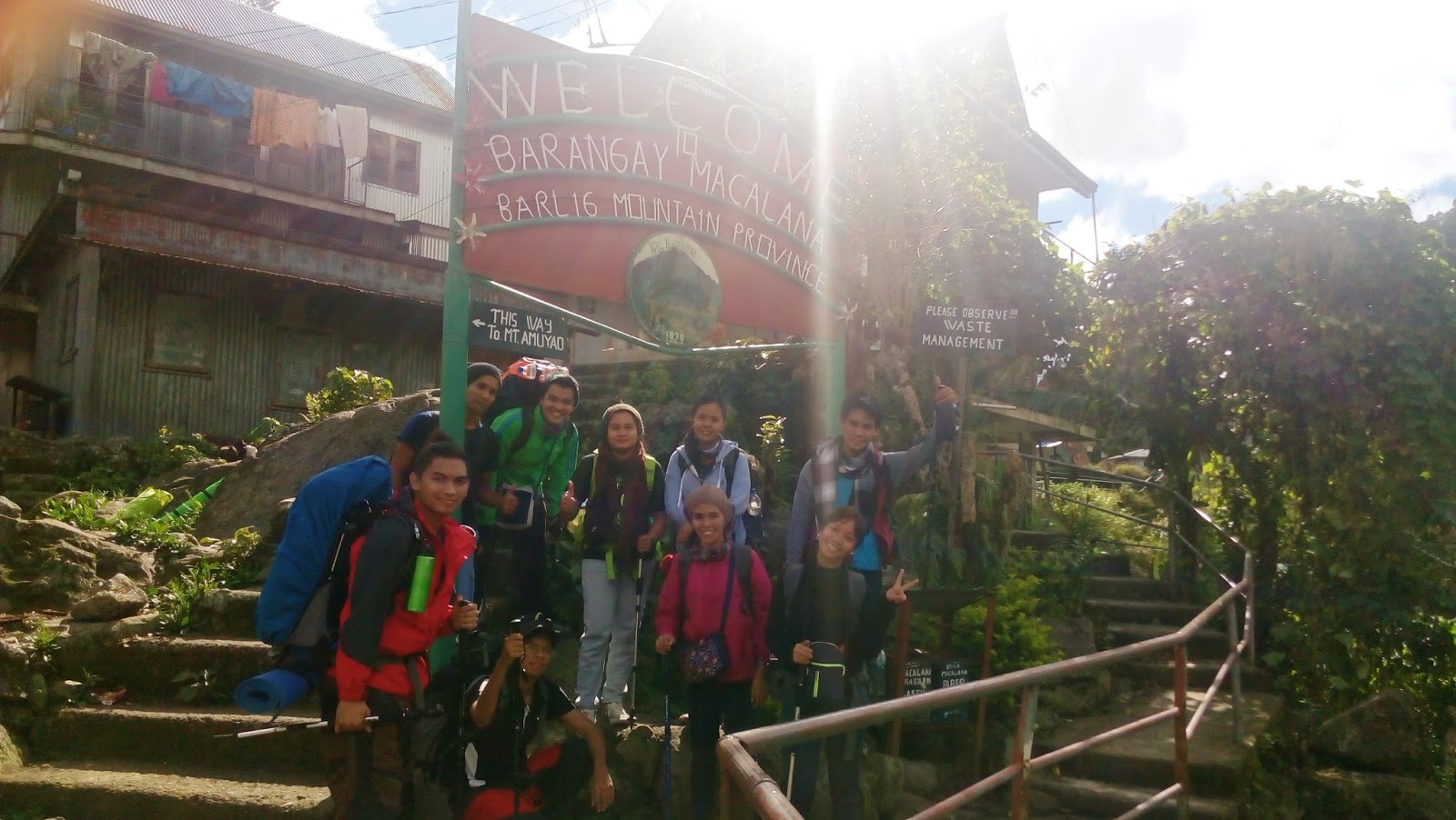


At last!, We were back in Cordillera, after a year of climbing mountains, were bound again to complete our bid for climbing Philippines highest mountains, and this is the 2nd sequel of PH's 10 highest mountains. Packed with courage and enthusiasm were all excited to do one of cordilleras greatest traverse climb,. It was not only one of the hardest we did but it was the most amazing climb I did this year. Joining me this time are the pioneers of our organization, as we were total of nine.


BACKGROUND:

Mt Amuyao is PH's 9th highest mountain standing at 8,864 ft, It is situated near the border of mountain province and Ifugao. Its summit is where a tower of two large network in Ph is located. Its trail is one of the hardest and greatest trail in Cordillera after Napulauan and ugo,. The trail will start in the  humble village of Barlig up to summit passing down through the ancient villages of mountain province until reaching the worlds famous Batad rice terraces in Ifugao that served as our exit point. Its a strenuous hike of 31 kilometers crossing two provinces and countless of rivers plus death defying steep and narrow trails tested our toughness, adaptability and resiliency. We took 52 hours and 35 minutes to complete the whole traverse with a difficulty of 8/9.


note: (Mt Amuyao is not for beginners doing a traverse climb is very dangerous especially on the rainy days)


Day 1 Barlig to Mt Amuyao Summit

The trail started in the humble village of Barlig


01.30am when we arrived in Barlig after 2hours of travel time from Banaue. and 11 hours of travel from manila. While we were in Banaue we packed and buy foods before heading to Barlig. It was my first time in Barlig. The sun was shining bright on the afternoon we took our bags and registered on Barlig Police station and started paying our fees, the weather was cold and it was only 2 weeks when mountain province was struck by a typhoon. We met our local guide who resembled carrot man of Mayaoyao.


We commenced our trek at exactly 02.30pm after we fixed and geared our things . The first leg of the traverse was a mid steep ascent up to the pine forest area. A preview of the summit was visible to the naked eye, there were a lot of discreet moments not to disturbed the overwhelming view, a feeling of satisfaction. A landscape shaped by hands of creator, we were so mesmerized to see this beautiful area of Mountain province that we didn't notice that we were trekking for 3hours until dawn.


It was exactly 05.30pm when we felt the first chill.  we knew that it would take us 6hours to climb summit so we expected to summit at night.


The pine forest was one of the best part of the first leg


It was a continues sub steep ascent and a well established trail with a nice breeze from the pine trees.


It was when around 06.00pm when we arrived on the first waiting shed of the summit, It was already dark when we put our 2nd layer of cover. We geared our lights for the final 3hours of ascend to the summit.


The 2nd leg was hardcore, major assaults welcomed us, as we climb higher and the night is getting darker until total of darkness engulfed us. There was a sudden drop of temperature and a bit of rain. We pass through the man made staircase built by locals.


1hour after 07.00pm major assaults still pounding our legs on our way up still no sign of summit. I was in the middle as we were divided in 3 groups. Still overwhelming with power I continued to push through after rehydrating my body.


exactly around 08.00pm when I finally felt my leg muscles starting to wobble. It was still full of assaults and we were bit exhausted, It was totally dark.


The lead team were my climbing buddies from cannon, I was in the mid, while Gerald, Erika and Lemuel were in the back.


After 30 minutes of walking we finally reached the water source at exactly 08.30pm we were bit tired and gust of wind around 30-40kph hit us. good thing were wearing wind breakers.
It was also due to temperature drop that we were walking a bit slow.

We rest for a bit, as team cannon, Daryl and friends decided to go ahead the summit was just an hour away


I waited for the last team to arrive as I am there to assist them. It was roughly around 9.00pm when they arrived on the first water source
.


We continued trekking up to summit at roughly 09.05pm and push through, the final leg of Barlig to Mt Amuyao summit was the most tiring part of the day, It drained my energy to the point of questioning if we can make it up to the summit. many factors have affected our ascent because the gust of wind kept on pounding us with chilling factor and it was raining at the same time.


It was when 09.38pm when we arrived at the knife edge section, strong gust of wind reaching 70kph pounded us as we make it up, just I thought we were close to the summit but it was a continuous 30minutes of assault before we could reach the Tower. Roughly the weather was a degree lower than 10.


We took 7hours and 35mins finishing the first 7 kilometer leg before we could camp on the summit.. We reached the bunker at exactly 10.05pm. The bunker was an old storage room, but converted to a house catering climbers who climb Mt Amuyao.  It was first come first served tired and weary, we still manage to cook food and set tent outside.  There was also a large group of mountaineers inside the bunker.


10.45pm was when we finished eating,  I cooked nilaga baboy (pork stew) eventually my team mates were already asleep, when I got outside, Gerald and Lemuel were having a massage session. I joined them, good thing I brought Tiger balm, I felt at ease on my back pain.


It was 11.00pm lights off and it was a chilling night.


DAY 2

MT AMUYAO SUMMIT - PATYAY VILLAGE

Good morning summit!

We woke up with chilling temperature roughly around 5-8 degrees C, Daryl, Floro and me slept inside the bunker, because it was already full and the rest of my teammates are outside.
The sun was not shining on the great Sunday morning, and it was raining like crazy.


We hurriedly packed our stuff and started to boil water until all of us were already awake at around 06.00am. We were expecting a 14 hours trek that Sunday, although we were having second thought but we commenced our trek at exactly 06.15am


Mt Amuyao summit is full of pines and different fauna the descent from summit to pat yay village was estimated 6 hours of trekking


we continued descending down and still gust of wind around 50-60kph pounded us, the rain kept on pouring constantly and there are no signs that it will stop.

07.45am after descending  for about 2hours we reached the mossy forest.


many traces of the previous typhoon were present along the trail


The rain suddenly poured hard as we continued until we reached the waiting shed area at around 09.00am.  We push down descending via diversion road as we saw a lot of typhoon aftermath effects on the part of Amuyao, there were many land slides and fallen trees


the trail was too dangerous so we were cautious. .


We didn't noticed the time and we were starving, as to when I checked my watch it was already 10.30am


We crossed the first river crossing down to the flat area of Amuyao at around 11.30am after 5 hours and 30 minutes of trekking.


and crossed another river again!


and again . .


non stop. .


until we reached the first view deck of pat yay rice terrace. . I CANNOT FIND any words to say but it was overwhelmingly awesome!


these ancient structures were sculpted by mans hands thousands of years ago long before the Philippines became nation. It was always nice to see and know the culture of the cordilleran people. Even when we were kids we were taught in school of how the cordilleran people built the rice terrace


but it was fascinating to see it in real!


It was around 01.30pm when we reached Pat yay village, an ancient cordilleran village known to natives as resting ground of mountaineers doing a traverse and rev trav. we were 2 hours late on our itinerary.


It was a sanctuary for mountaineers, we decided to spend the night in pat yay because our guide recommended that it would take us another 7hours to reach Cambulo, plus the trail to Cambulo is very dangerous especially in the evening add the rain factor we decided to camp in pat yay! We rent a house in pat yay village for about 145 pesos each person pat yay village has no electricity but the weather was still cold and chilling at night.


03.00pm we prepared early dinner after it, hola siesta!!! We massage each other to relive the pain in our aching bodies, I had 18kg back pack that I carried  for about more than 27hours. We washed our things and set our sleeping bags to an early evening sleep.


ahh! massage was good when your body was aching


Lights out at around 07.30pm


DAY 3


PATYAY VILLAGE TO CAMBULLO VILLAGE TO BATAD SADDLE


Pat yay kang bata ka!  13 hours non stop trek!


The next day we woke up by rain and very cold temperature roughly around 10 degrees, still raining as we hope that the sun would shine soon.

we woke up the next morning at around 04.05am to prepare early breakfast for our morning assault on cambulo village, still dark and sleepy we needed to cook rice , and the water was freaking cold as ice!


TO BE CONTINUED. . . . . . 


continuation Mt Amuyao Part 2


Linggo, Disyembre 18, 2016

MT MACULOT (TRAVESE)


Sept 4 2016
Brgy Siete Cuenca batangas.


At 7.30am,  On bound, we were going to Cuenca this weekend after successfully climbing Mt Manabu last week,  It was suppose to be our tree planting event however, due to seeds unavailability we proceed to continue our trek as a regular day hike exactly 1 week ago, we were on our way to visit one of Batangas famous mountain, Mt Maculot.


It was way back 2010 when my friend invited me to climb maculot, but I was so naïve that time that I refused to participate. It was my first time visiting Mt Maculot and this time we organized a joint hike from two aspiring Backpackers group. UGOEn and PMS,. This was our 3rd joint hike together after successfully climbing Mt Manabu last week.

Our group was partly mixed of some newbies and some veteran climbers, We organized this climb as a welcome activity to the new members of our organization. Maculot, was also known to many as a mystical and beautiful mountain after its counterpart Mt Makiling in Laguna. It is also a famous destination to tourist especially the Rockies that brings you 180 degrees view of Taal lake.


We were 9 including the team leader of PMS Aaron Moreno one of my climbing buddies, we were excited this time because Maculot is a known mountain to many in the southern most part of Batangas.


8.30am,  we were exactly at mountaineers store in Brgy Siete We were welcomed by local guides and tourist as we geared up in preparation for our traverse hike. Our trail will start in Brgy siete up to the campsite, left turn to the rockies and up to the summit traversing Grotto part, which on a scale of difficulty we have conquered 4/9 and took us 6 hours and 15mins.


We started our trek at around 9.00am, guides are required in Maculot as their new policy after a mountaineer died in the mountain way back 2014. The first part of the trail was a concrete it was an easy 10mins trek until we reached the rough area, the trail path became narrower after 30 mins of trekking. We saw signs of deforestation on the trail, we also heard of loggers cutting trees on our way to campsite.  our guide was well experienced guide. He told us that Logging in the area of Cuenca Batangas is prohibited by the local government. So I was a bit disappointed when I heard his stories. It took us a total of 30mins to reached the first view deck at around 10.30pm. 


It was also the resting point of some hikers, the camping site was about another 30mins away from the first view deck. At around 11.00am was when we reached the campsite on Mt Maculot, we were a bit surprise of the stores selling everything to hikers and trekkers, the rockies area in mt maculot was about 10mins away from the camping area, We decided to unload our bags on the camping area so that we could visit the rockies part of Mt Maculot which was a famous land mark of Cuenca Batangas.


The trail to rockies was not establish there were a lot of rope segments connecting the upper part to the lower part of the trail, as we ascend we saw already a preview of the world-famous taal lake. At around 11.18am was when we were already on the summit part of the Rockies area of Mt Maculot, the whole rockies part area has a 270-degree overwhelming view of taal and the nearby towns of Batangas city. That time we were already enjoying the view and taking good shots from the north and the south side of rockies part.


 Mt Maculot was also known to many as a mysterious mountain, fact that there was once a mountaineer went missing for 10 days in Mt Maculot and was found dead after 10days, It was one of the saddest moments of Philippine Mountaineering Society, operatives have investigated what was the cause of death of a mountaineer in Mt Maculot It was found out that prior to the death of that mountaineer he went to Mt Maculot on his own after successfully completing a major hike in Sibuyan island Romblon. 

He went up to the rockies part area on his own to take a picture of the sunrise he left his backpack on the jump off area without leaving a notice. Operatives found his body 10days after declaring he was missing, findings said that he got accidentally fell off 300-400feet below the rockies area.


 At around 11.45am was when decided to went back on the camping area of Maculot, after successfully capturing good shots. We were accompanied by our guide he told us the whole story of the tragic death of one of our colleagues in mountaineering.


It was past 12noon when took lunch on the camping site, that time we saw many other climbers who were that time just came back assaulting the summit of Mt Maculot. After our lunch we took a rest for about 30mins and resumed our trek at around 1.00pm I noticed that the clearing that day was not good due to bad weather and we expected rain that's why we packed our bags. The bad thing that day was I failed to bring my bag cover so we modified the garbage bag we brought and made an improvised bag cover. We resumed our trek at around 1.05pm, by that time fog was already engulfing our path, It seems that we were walking on an enchanted garden filled with mysterious fog. We decided to push through to summit even when we knew already that it will be raining. The good thing was that my the new members of our team posses great fighting spirit they were climbing hard with us.


01.30Pm was when all of a sudden the temperature drop and It started getting much cooler, so we enjoyed the whole ascent. The second part of the trail was like Mt Pulag Mossy forest, it also resembles wild bore trail in Mt Makiling, a mountain I previously climb last 2 months ago.

We continued pushing through, up to the thick fauna of Maculot, the presence of fog was also a major factor that we were trekking slowly, we were enjoying the whole trekking while relaxing, the wind was cool and breezy, all of us were silent that time, I always experience a sense of great sensation when hiking a mountain that's why I climb frequently.


At around 2.15am was when we reached the summit of Maculot after trekking for about an hour, It was a steady chill climbing relaxation on a great Sunday afternoon. We rest there for 30mins and met other hikers descending back to campsite, by that time I already expected a 900masl high altitude, although we were not been given a good clearing but It was so chill climb that I experience again satisfaction to the exquisite level of climbing a mountain.


We did the traverse climb that day so we were not going back from the point where we started, the clearing was a bit gloomy. I expected a great view of the summit and the whole of taal lake but after resting for 30mins we eventually forgot the clearing and took great pictures of the summit. From my memories, I have totally reached a total altitude of 40,000ft altitude since january this year and I'm planning to close my total altitude to 50,000feet at the end of this year. This was my 9th summit this year after Mt Manabu last week.


It was when 2.00pm when we decided to descend to the grotto area, the other it was on the other part of the mountain, the 3rd part of the trail segment was now muddy and slippery. It was due to heavy raining early morning, experience climbers are the one's that are doing the traverse part of Maculot because of the trail class, the descent from the summit down to grotto required a lot of rope segments and slippery rocks.


We carefully descended down, the mud was about 4 inches thick In my trekking shoes, it was a bit messy and we managed to descent successfully down after passing two rope segments. The descent was a bit comparable to Maktrav reverse trail and was also mossy. Our phasing was a bit slow because of the trail condition. The last part of the trail was a 20meter rope rapel down to grotto area, It was said that It was impassable when it is raining, although a reverse traverse trail was not recommended when raining but it is good conditioning hike for advanced climbers who are seeking for great tune up climb, It can also be a good alternate source of tune up climbs aside from Mt Makiling.


We took a rest for a bit and rehydrated our bodies, the fog was already gone, a good clearing of grotto area was already visible to my naked eyes, from our resting site it was now a swift 20mins descend going to grotto area after the rock segment. Now we were back to the familiar grassy part until we reached the grotto area. It was already 4.00PM, we rest for a bit. now the trail going to the grotto area was now far more established than its counterpart on the campsite area, It was composed of hundred of steps going down
After resting for a while we trail run down to the exit point for about 30mins, by 5pm we were already back at our jump off point. The entire traverse took us 6 hours and 30minutes excluding the phasing time and lunch. And at last, we finished another major climb that marked my 40,000ft altitude, this was the 9th summit we conquered this year, I thanked my hiking buddies for this another wonderful major hike we completed. I am looking forward to our major expedition in Cordillera this coming October so we are preparing for next month.


Cuenca, Batangas
Major Jumpoff: Mountaineer’s Store, Brgy. 7 “Siete”, Cuenca
Exit point (traverse): Brgy 5 (to Grotto), Cuenca
LLA: 13°55 N; 121°2 E; 706 MASL (Rockies) / 930 MASL (summit)
Days required / Hours to Rockies / summit : 1 day / 1-2 hr / 2-4 hr
Specs: Minor, Difficulty 3/9 (Rockies); 4/9 (Traverse) Trail class 1-3.
Features: Scenic views of Taal Lake, rock formations, forests


Linggo, Agosto 14, 2016

Mt Makiling Traverse


JULY 17 2016
Sitio Jordan Brgy San Felix Sto tomas Batangas                              


At 8.15AM,  Close to home lies at the heart of Laguna facing Calamba City my hometown from its north face stands a mystical beauty of Mt Maria Makiling. An ancient mountain familiar to many as a mysterious place ever since the time of pre-colonial Philippines.

She was named after Maria Makiling a diwata (Goddess fairy) in Philippine Mythology and stands at 3580 ft in altitude on its highest peak. Makiling, a rain forest mountain has a thick vegetation and is home to rare flora and fauna. It has 3 major peaks, peak 3 is connected to peak 2 via traverse Sto tomas to UPLB trail, while peak 1 has a separate trail.

 My first climb on Mt Makiling was on the year 2009, It was also my first ever recorded major and minor climb on my hiking activities. After 6 years since I first climb her, I am finally back doing a travese climb via SIPIT TRAIL from our entry point Sto Tomas Batangas, to UPLB (University of the Philippines Los banos Laguna) college of forestry as our exit point. It was so far the most challenging day hikes close to Metro Manila.


 Joining my adventure was Gerald Kumpan my hiking buddy and some of my new friends we met. The entire travese took us 8 hours 50 minutes of trekking with rope climbing and trail running. again we were the last team that took off, there were 33 groups ahead of us.

At 8.30Am,  we were already on our way to sitio Jordan Brgy San Felix Sto tomas Laguna, We headed to the major jump off point of Mt Makiling where we got our guide. We commenced our trek 15 min after we settled our Guide at around 9.15am. 

The first part of the trail reminded me of Mt Arayat via Magalang side, it was a continuos chill trekking, the thick vegetation of Makiling  gives sanctuary to indigenous plants and Animals. The trail was mossy and wet, it was composed of 30 stations before peak 2, and another 30 station after peak 2 on the UPLB side. I estimated a consistent 150-200 steps interval per station. We met our new hiking friends Marnie, Yul and 3 of there companions as they were total of 5.


At around 10.00am,  was when we arrived on the last water source and the first resting area of station 4, after a nonstop tune up trekking. We were a bit fast, all of us were eager to catch up because we estimated 10 hours trekking and by the time we finished the whole traverse on the other side of Los Banos it will be dark. We resumed after 10 minutes of break. 


At 10.15Am, on station 7, one of our hiking buddies decided to cancel the climb, we were on the 2nd resting area, Yul, one of his companions keep on cheering him but he was hyper ventilating due to fatigue that one of our guides decided to bring him down. Marnie said he didn't sleep prior to our climb and it was his first time climbing a mountain. We felt sorry for him knowing Makiling travese is not your ordinary walk in the park, in fact it is one of the thoughest major climbs within the vicinity of Metro Manila, so all climbers must be prepared and have a good sleep. I have been climbing mountains ever since 2009, although not consistently but I can assure you that never under estimate a mountain. Makiling, way back 2005 was more difficult to climb than it was now, the fact that Melkas campsite can accommodate more hikers because that time, it required two days to complete the whole traverse. While a day hike seems impossible and demands more physical strength. 
On the other side Makiling was famous as a Mystical Mountain, It was the same year  when one climber died in Makiling he fell forty feet on Palangana segment on Sto tomas side while descending, authorities said that there group were following a strange sound of children playing. It was also in 2011 when 2 UP students mysteriously disappered and found dead in the mud spring area after few days on Los Banos side. There were also reports of missing groups in Makiling due to heavy fog, so take precaution when climbing and presence of mind is a must.


10.30Am, was when we resumed our trek until we reached the first view deck, by that time I estimated a 2000ft altitude at around station 11. Tall grass resembles the trail in Tarak Ridge, I also saw Mt Maculot and Taal lake from a distance. After a brief trekking on the grass part segment, we entered again into the forested part. We push through to station 11, 12, 13,14 until we reached station 15 which is considered the most limatik part of Makiling.


11.30Am, We decided to eat lunch on station 15, limatik's were swarming from every direction, although I was hesitant at first but I eventually had fun eating lunch with this cute creates of the mystical mountain.  Some Limatiks bit me as if I am their lunch. We catch up to some groups who left ahead of us, we were fast and our momentum kept us moving forward. We resumed our trek at 12.15pm, the weather  was a bit gloomy when we arrived on haring  bato area at around station 16. 


  The hardest part of the traverse was on Melkas Ridge Just above the haring bato. It featured a lot of rock climbing segments up to peak 3, consisting of 85-degree assaults where we needed to crawl and used our contortion skills to pull ourselves up. 


It required a physically demanding lower and upper body strength to pass through melkas ridge a challenging 30mins assault with rope climbing. The gust of wind was strong and the view was exquisite just before peak 3, so we took pictures of the awesome view.


At 12.40pm,  We arrived on peak 3, it has a great camping area for campers and the clearing was also great, but we didn't waste time, so we continued our trekking via wild bore trail. It is the trail connecting from peak 3 to peak 2. Limatik Presence was still a major factor that we were trekking fast, we were considering the time required to reach Agila Base,  it was 4 hours from peak 3.  and another 1 hour from Agila base to UP forestry .


Wild bore trail consist of high grass bushes with some flora species covering the trail, I
saw some Poison Ivy or LIPPA a rare flora found on some mountains in the Philippines.  It was like a roller coaster trail up and down that resembles the ridge between the North and South peak of Mt Arayat. 


I saw the North face of Mt Makiling by some parts of the trail, facing the astonishing view of my hometown Calamba City from a distance. Gerald and some of our new hiking friends were ahead of us, they were fast, Yul Asuncion my hiking buddy and me were the last, we were trekking spontaneously, our momentum kept us moving, until we reach peak 2 after one and half hour of sprint trekking.


At 2.45pm, We continued our sprint trekking without noticing station 30 of peak 2, It was already 15 minutes when we noticed that we were descending peak 2 and on our way to Agila base, passing station 30 where our buddies were waiting for us. We decided to rest for a bit and Yul climbed up again to peak 2 to pick up our buddies who were resting that time on station 30 or the summit. We regroup at around 3.14pm and continued descending to Agila base, again a one and half hour of sprint trail running. 


We pass station 25 and rest for a bit, finally we saw a clear view of the Los Banos side. From our point of view we saw the whole of Laguna Lake, Talim Island, and the nearby towns of Los Banos, Bae, Calauan up to Sta Cruz Laguna.


At 3,25pm, We just passed through the wooden stairs made of bamboo, from there we run non-stop passing station 24, 22, 20 and 18 for one hour and six minutes with no rest until we reach station 10 of Agila base by 4.30PM. 


Los banos side has more establish trail compared to Sto tomas side. station 20 to Agila was comparable to Tarak ridge's trail to Papapaya River. Our water source ran out again by the time we reached Agila. Thankfully Agila has a sari sari store that sells water and mountain dew to hikers reaching Agila, we met other hikers resting in Agila base by that time we have already conquered eighty percent of the whole traverse which took us 7 hours and 30 mins.

At 4,50pm, After resting for 20mins we continued our trek down to UP Forestry, one option is to ride a motorbike which will cost you 100 per head down to UP Forestry but we decided to continue our trek because we were hardcore, we wanted to finish the whole traverse by foot. I switched my shoes to sandals and we started trail running again by 5.00pm, 10min after we departed Agila Base.


 We run non-stop on the cemented trail passing mud springs, Makiling Nursery until we finally reached UP forestry or station 1 by 6.10Pm. we met several hikers on the Exit point where there were establish comfort rooms for wash up.  Exhausted, and thirsty we arrived with smiles on our face knowing that we enjoyed the whole adventure, our athletic stamina kept us on track. We have completed the whole travese which took us 8 hours 50 mins

I am planning a Maktrav 2 this September as our scheduled tune up climb for Mt Amuyao on October 29.

It was nice to be back on Mt Makiling my first ever mountain to climb, so much changes have occured when I first climb it way back 2009. I thank my new friends we met for this another wonderful Day hike adventure. 


MT. MAKILING TRAVERSE (MAKTRAV)
Sto. Tomas, Batangas and Los Banos, Laguna
Entry point: Sitio Jordan, Brgy. San Miguel, Sto. Tomas
Exit point: UP College of Forestry, Los Banos, Laguna
LLA: 14.13°N 121.20°E, 1090 MASL (Peak 2)
Hours to Peak 2 / days required: 1-2 days / 5-8 hours
Specs: Major climb, Difficulty 5/9, Trail class 3 with roped segments
Features: Roped segments, rocky face, limatik, rattan, tropical rainforest


source: pinoymountaineer


Biyernes, Hulyo 8, 2016

2ND Environmental Summit


June 20 - 24
MEGATRADE HALL


I have been busy for a week doing a report on my work in sales and finishing my blog in Tarak Ridge when my good friend and mountaineering buddy JM invited me to attend the 2nd Environmental Summit as an observer, it was hosted and manage by Artiste Space in partnership with SM and DENR. Its aim is to tackle, showcase, propagate and raise awareness on environmental protection. It was a 5 Day event showcasing new technologies on: 

Solid Waste Managment, 
Reduction of Carbon footprint 
Converting Waste to Energy Technology
Role of the LGU's and private sector on proper waste segregation


and the role of social media in propagating Environmental Awareness especially to the youth.
I have been an advocate for Environmental Protection since 2008. I read books about Climate Change and been actively participating Environmental Symposiums on my college years, and yet I only realized the serious problem of climate change when we were seriously affected by massive floodings caused by tyhpoon Ondoy on 2009 and HABAGAT flooding on 2012. 

I began appriciating the environment more when I started my mountaineering activity 6 years ago. Although I was not consistently climbing for the past 5 years, yet I have been aware of the serious problem of climate change. Our mountains and rain forest are the center of biodiversity, it is home of our animals and different kinds of species yet it is threatened by us humans. 


I had a wonderful time talking to different kinds of people whom I share passion with. I was astounded by their willingness to take part of change considering their social status in life. 
Rich or Poor we share the same world, we use the same resources that comes from the environment, and so we have the responsibility to protect our source of life.


I listened to lecturers from Japanese LGU's on solid waste management as they have discussed how they turned their waste into energy, they were so organized that their government has been actively supporting private sectors and local household on segregating waste decades ago.


Given their technological advancement, they have established facilities converting waste to energy all over the world with the help of private sector. They also shared their experiences on recycling. 


Different LGU's shared their experiences on waste segregation, although we were not yet advance in technology as our Asian Counterparts, it was overwhelming to see our local governments effort on taking initiative propagating waste management on their respective areas.


I met Kiko Rustia Born to be wild host and TV personality, he has been an advocate for environment ever since he started doing TV and been actively participating Environmental forums all over the Philippines. He was our guest speaker, he said that the role of our Media is very vital, on raising awareness on environmental protection. Sadly our media focuses more on negative things and trends. 


We seldom heard news about the Environment in the main stream media He said, and that's why we must share our part in fulfilling the unfulfilled.

I talked to Kiko and he has been to many places in the Philippines particularly on remote islands, he has been also into mountaineering for quite some time observing our forest, and many of our wildlife are in great threat of extinction due to human activities, that is why we need to raise more awareness to people and we need more people to engage and be part of this change. It's not over but we have to start now!

I have been also a witness of this dramatic changes in our environment whenever I climb mountains. Some of our Eco parks were victims of Ilegal logging and kaingin. Although it is protected by our law, It is always heartbreaking to see such illegal acts. 


The program Ended with a short Chit chatting, I talked to DENR representatives and they've shared their insights on the new projects of DENR this year. 

I also saw different exhibitors showcasing new technologies from waste segregation to water treatment. the program ended with a bang! I just hope next year many would participate in this very informative event.